Crossing the Thorung La (5417 metres)
As
the two of us stumbled down the icy slope in near whiteout conditions, a
forlorn hunched up figure appeared out of the mist. As we got closer I could
see it was the slight figure of a Nepali porter sat in the snow. His load was
loosely covered in a plastic sheet, which was blowing frantically in the strong
wind and this seemed to be preventing him from getting up. We attempted to
secure the plastic sheeting around the basket and helped him to his feet. I
could see the fear in his eyes as he muttered some words of thanks but these
were drowned out by the wind. It was then I noticed the rest of his attire. He
was certainly not equipped for crossing a high Himalayan pass in such bad
weather. He could hardly walk in the poor quality trainers he was wearing and
as the two of us moved on we noticed he was no longer with us……..
It
had long been an ambition of mine to go to the Himalayas but being involved in
education for many years it was not possible to get holidays at a suitable time
to go trekking there. It needed to be pre or post monsoon (Oct-Nov). Now I had
taken early retirement that opportunity became available. Trip booked and paid
for to go in mid October 2014 with KE Adventure on the famous Annapurna Circuit
trek in northern Nepal, KE are based in Keswick, and I can thoroughly recommend
them. I set off from Heathrow on Qatar Airlines via Dohar in Qatar to
Kathmandu. (Seven hour and five hour flights respectively) Early next morning I
met our guide Shami Sherpa and the other four members of the group from UK and
we set off on the long drive on the Prithvi Highway. The group included a
doctor, a dentist and a vet so all orifices seemed to be covered. This
landslide-prone and heavily congested highway connects Kathmandu to Pokhara. On
the outskirts of Kathmandu we picked up our four porters
After
five-hour drive with a break for tea we turned off north to Besi Shahar where
we stopped for lunch and transfer to four-wheel drive vehicles. After another
four hour drive up a rapidly deteriorating track, which we had to get out and
repair several times we reached our first lodge for the night at Jagat. The
following day involved an early start, up at first light and off walking by
7:45 am. It was a beautiful sunny day, 28 deg C and much to my surprise we were
in shorts. We walked for about four hours until lunchtime at a teahouse past
spectacular waterfalls in the Marsyangdi valley. Another two hours or so walk
in the afternoon saw us reach our next base at Dharipandi (1860m). Leisurely
evening meal and bed by 9:30 pm for an early start next morning.

Inside the teahouse on the Thorung La
This
pattern was repeated over the next nine days as we proceeded around the Circuit
with ever improving views of the Annapurna Range and Manaslu (8163m). The
scenery gradually changed from rain forest at the start up through deciduous
woodland in autumn colours through to high alpine scenery above the tree line
at about 4000 metres and eventually desert terrain on the edge of the Tibetan
plateaux. The crux of the circuit is the crossing of the Thorung La at 5417
metres and it was important to get acclimatised for the ascent of this pass so
we had a day off in the regional centre of Manang. Even so this was not really
a day off as we had an acclimatisation morning walk up to a viewpoint near a
glacier at 4000 metres.
By the time we reached
Ledar for the night at 4,200 metres, nine days later it had got a lot colder
and the sky had clouded over. The guides assured us that this was often the
case in this area. The shorts had been put away and the hats, gloves and duvet
jackets were out! Ate our tea fully clothed in a cold dining area followed by
early night. Porridge for breakfast and woke early to superb sunrise over
Annapurna III.
We
continue our trek on the eastern side of the Jarsang Khola valley, with views
back to Gangapurna (7454m). Beyond a bridge, a steep trail climbs across scree
to the base of the pass at Thorung Phedi (4420m) by 10:30 so too early for
lunch. To make the pass crossing easier tomorrow, we hiked up for a further
hour and a half to the lodge at Thorung High Camp (4925m). This proved to be
hard work up a series of steep zigzags and I felt quite light headed and knackered
at the top. We settled into our rooms and had lunch. The dining room was
especially busy with a lot of other trekkers. A large group of Israelis were
made their presence felt. Some of the Israelis seemed unwell and asked us what
they should do. They felt nauseous, dizzy and had no appetite. We told them to
drink plenty of water and if they still felt ill to descend to the lower camp
at Thorung Phedi. We also suggested they took some Diamox to reduce their
symptoms of what was obviously Acute Mountain Sickness. They had no idea what
we were talking about and seemed much unprepared for the altitude or the
conditions. It then transpired that they had no guide and very few porters.
Little did we know what was to become of them. (See press cutting).
After
this we went for 100m climb up to viewpoint and the obligatory photos. By now
the weather had deteriorated even more, clouds had rolled in over the tops had
it had got even colder. None of the guides seemed bothered by this as they said
it was quite often like this. By teatime the snow arrived, lightly at first but
by mid-evening it was much heavier with a breeze. Little did we know but
Cyclone Hudhud had arrived!
We
left the crowded dining area and off to bed at just after eight for an early
start at four am next morning. The early start is normal from here as it is
important to get over top of the Thorung La by mid morning as the wind gets up.
As a result of the bad weather but it was decided to start even earlier than
normal. It would be up at just before 4 and off by 5 a.m. I had a poor night’s
sleep and got out in the night for a pee twice and it was still snowing.
By
about 3 a.m. I could not stand listening to my heart pounding away in my chest
any longer and got up with the guide and porters for an early morning brew. By
now the snow was 6 to 8 inches deep at the camp and it was snowing even
heavier. It soon transpired that nobody else in our group had slept well either
so I felt better already! Our doctor gave me half a Diamox tablet as I still
felt rough and after a breakfast of porridge we set off in the dark in heavy
snow just after 5 am, The next four hours passed slowly as we plodded up a
series of zigzags through deepening snow with the head torches of other groups
seen dimly through the mist below us. These faded away as we went higher into
the storm and whiteout. After a while it proved hard for the guides to find the
way in the poor visibility and we reached a point where there was considerable
indecision by the guides. Fortunately a group of locals appeared with their
ponies and seemed to know the way on and we pushed on in their tracks. At just
after 7 a.m. we reached a teahouse, which we were told was about half way up.
It was still snowing hard and the flakes were the size of ten pence pieces or bigger.
After a quick brew stood in the
snow from the teahouse we pressed on, the wind now started to pick up and the
spindrift blew around mixed with the falling snow. I thought back to when I was
packing my gear at home and threw out my goggles, thinking, “I won’t need
those!” Oh well, too late now. We got slower the higher we climbed and after
what seemed like hours the ground levelled out and the summit flags and tea
shack loomed up out of the mist. We had reached the top of the pass at 5417
metres. It was just after nine and had taken us four hours, not bad in the
conditions. It felt bitterly cold. I looked at my thermometer it was –9 deg
Centigrade and with the wind child about equivalent to –35. Some of our party
including myself managed to squeeze inside the small teahouse along with a
number of other weary looking soles for a hot drink and some of us even found a
seat. After a brew and a brief chat I managed to compose myself to take a
couple of shots inside the building and a couple more of the summit flags and
stupa as we left. Leaving proved difficult as a French party were trying to
force their way in to the already over crowded teahouse. At this point I lost
it and shouted at them to get out of the way using a well-known Anglo-Saxon
phrase. Anyway this seemed to do the trick and we were all able to exit leaving
the French in our wake!

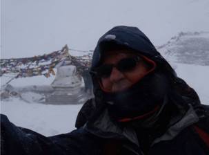
The summit prayer flags Me at the top
By now other groups had passed
straight through and you could just about make out the route down. The path
descends steeply down to the village of Muktinath (3700m). A descent of near
2000 metres and some 5 hours away. By now the wind was even stronger and brief
gusts nearly took you off your feet. As we descended we came across several
porters from other groups in difficulties, mainly because their loads were not
covered properly and the plastic sheets covering it was acting like a sail.
Some of us stopped to help secure several loads but you could not stop long as
it was too cold and windy.
It
was a bit later that I and another in our party came across the hunched up
figure of the porter mentioned above. He was unable to walk and I guess he had
frostbite. I still think about him and wonder if he made it. We pressed on and
in the mist our party got split up as various people stopped off a pee. Most
people male and female, just stopped at the side of the path in the snow, which
by now was over 30 cm deep and it was still falling. It was too dangerous to
wander far from the descent route which was along a ridge in the deep snow and
steep slopes on either side. Further on I saw several people who had wandered
off or slipped down a steep slope to the left struggling in very deep snow. The
whole slope looked avalanche prone to me. After about four hours of continuous
descent in poor conditions with very flat light due to the mist and my
reactolight glasses a line of buildings appeared out of the mist. This proved
to be Champarbuk, a welcome break and the wind had dropped with the snow only
falling lightly. As I sat down inside the main teahouse with some of the rest
of my group I realised how hungry I was. Foolishly I had left my chocolate bars
in my rucksack rather than my pocket and they were frozen solid. After a
warming mug of tea and some melted chocolate we set off for a further two hour
descent to Muktinath via a suspension bridge with the weather improving all the
way. Our lodge for the night was reached without further mishap. Slush in the
streets showed that it was getting warmer.
All our party eventually collected together safe and
sound at the lodge for evening meal of yak steak and rice and attempted to dry
gear, difficult as the electricity and heating was not working. It was then
that we realised that many others were having difficulties on the pass. By dusk
people could still be seen coming down the trail with head torches on and our
guides had found that numerous porters from other groups had not made it into
the village.

Sunrise alpenglow
over Dhaulagiri (8172m)
As I went to bed I could see a few
stragglers wandering into the village. I slept well that night and woke to a
beautiful clear morning with a fantastic sunrise alpenglow over Dhaulagiri
(8172m) the eighth highest mountain in the world. Over breakfast it soon became
clear that a disaster was unfolding. Many trekkers and porters were missing and
some already confirmed dead on the Thorung La. By early morning a few
helicopters were seen heading up towards the pass. At first twenty or so were
missing and the number gradually increased over the next day or so. It
transpired that, after one of us managed to see the BBC News website, that the
incident had gone global. We all managed to get messages out to our families
that we were safe by the end of the following day. Later we found that some of
the Israeli group we spoke to ended up being rescued from the top of the pass
having sheltered in the teashop overnight. Some had severe altitude sickness
and others had severe frostbite with lost fingers and toes. Some others had
tried to decent in the afternoon when the teashop owner shut the shop and left
and been caught in an avalanche while others had died of exposure. The last we
heard was that there were 39 confirmed dead and several people still missing in
the snow. We later saw a newspaper in Pokhara with pictures of the same Israeli
group who we had advised to descend at Thorung High Camp. It appeared that some
had done so but had set off too late from the lower camp and timed their
crossing of the pass at the worst part of the storm as they had set off too
late. We continued the trek over the next few days and returned to Kathmandu
via Pokhara.

The Israelis got in the papers!
Looking back I would say that a number of factors
contributed to the disaster. Firstly it was a freak weather event, as Cyclone
Hudhud was not expected to reach the Himalayas. Some groups were not fully
acclimatised. Some people including porters were poorly equipped for high
mountains and others set off too late in the morning. It is the responsibility
of anyone that hires porters to make sure they are fully equipped for bad
weather. Our guides issued all our porters with bad weather gear and this was
collected off them at the end of the trek. Various articles in the press tried
to blame guides for the disaster but I think that is unfair as some groups did
not have suitable guides with them and others were ill prepared for such bad
weather and lacked experience. Looking back the trek is a great walk but you do
need to take suitable warm gear, although you may only need it for a day or so.
I would certainly like to go back to Nepal sometime in the future.
Andy Hall