Explorations in
Upper Ribblesdale and Park Fell
Over the last three years
a number of members have been involved with speleological investigations in
Upper Ribblesdale and the slopes of Park Fell north of Ingleborough.
My attention was first
drawn to this area by Alex Fletcher of Red Rose and CDG. He was interested in Batty
Beck Flood Rising (SD 76727921) This is down the valley below Football
Cave (SD767792) and the water from both is known to go to Goat Close
Rising near Gauber House a kilometre or so further down Ribblesdale. Originally
the flood rising was just that a rising through boulders at the side of Batty
Beck right next to the road. Alex started a dig in dry weather and I went along
a few times to help him dig in autumn 2015. We smashed up and pulled out a lot
of rocks from the passage both above and below the water. When the water is low
it is now possible to enter a cave for a few metres and then the passage dips
off underwater to a depth of about 4 metres. In flood the cave is completely
flooded to the level of the beck outside.
We did some surface survey
work between Batty Beck Rising at Ribblehead road junction and Batty Beck Flood
Rising via Football Cave to ascertain the various relative heights. The survey from Ribblehead Rising past
Football Cave down to the flood rising showed that there was about a 7 metre
height difference between Football Cave Sump and Batty Beck Flood Rising Cave.
There must be open cave somewhere between the two. Diving and underwater
digging continues at this site with the help of other CDG members.
Using Google Earth Alex
had also spotted what looked like a resurgence further down the Ribble below
Lodge Hall Farm. This area does not appear on either the Northern Caves
Vol.2 maps of Ribblehead or Park Fell
but is a large area of limestone supposedly devoid of speleological features.
No caves had been recorded in the area, which seemed difficult to believe as it
is a large area of limestone. In early March 2016 he went for a walk in the
area and came back with tales of several cave entrances including a resurgence
and what looked like a flood rising cave. A couple of weeks later we set off
for further exploration armed with a detailed map, GPS and camera. We walked
down through fields on the footpath from the Selside to Ribblehead road towards
Lodge Hall Farm past a lime kiln and rising, which was obviously the water
supply for the farm. The first cave we came across was next to the track from
the farm to Nether Lodge and close to the barn at SD782778. This is now known
as Battersby
Barn Cave and is covered with corrugated iron sheeting. An open
rift is a 3 metre climb down leads into
a crawl that could easily be dug.
We set off down the
shallow valley to the south east with a limestone scar on our left past a
number of depressions and sinkholes which seemed to drain off the drumlins of
Plantation Rigg to the north. Below the scar is a well drained field and dry
valley leading down towards the River Ribble. Under the limestone scar and
below the wall was an obvious cave entrance about a metre square with water
just inside and obvious signs of floodwater issuing from it and the surrounding
area.
Further down towards the
river in Lodge Hall Cow Pasture Field we found another small cave with water
coming out of it. The main rising was just over the wall from here and issued a
sizeable stream. We carefully recorded each site location and took photographs.
As we made our way back to
the farm we heard someone shouting to us across the fields, the farmer from
Lodge Hall, George Mason. We went over to explain what we were doing. He was
rather wary at first but mentioned that others had been looking round the area
a few months ago. He had been down to the flood rising cave, which he referred
to as Otterstone Cave, and the Cow Pasture Rising Cave site was
also known to him. In each case he had pulled rocks out with his tractor,
partly to see where it went and partly to get access to water for his sheep to
drink. We found that Richard Gibson had been looking in the area so Alex
decided to contact him. George also mentioned about several holes on his upper
land in Shaw Pasture field to the west of the main road. One of these he had
found when there was snow on the ground and had a draft coming out of it.
On a very wet day in early
April to had a wander over Shaw Pasture and Park Fell area above Colt Park
Wood. We found the two holes that George had mentioned to us along with an
interesting rising and sink area at the higher western end of Shaw Pasture. The
lower drafting hole appeared to be an open shaft capped by a few large rocks
and some old tree trunks. It looked like a really good dig. Some of the sinks
on Park Fell were also located including Pint Pot, Blood Pot and Park
Fell Rift. These were all taking lots of water but it was a very wet
day. There is another hole down a blocked rift between the two patches of
fenced woodland, Shaw Plantations Pot. This would also make and excellent dig
site and is in a line between Pint Pot, Shaw Pasture Pot and the rising.
Later in April with the
onset of drier weather we returned twice with digging and diving gear to
Otterstone Cave, this time Richard turned up to help. We made some progress and
George came along to see how we were getting on. We decided that the roof
needed some chemical persuasion to allow progress. There have been several
trips over the summer of 2016 after help from John Cordingley and his chemical
persuasion. Much material has been removed from the roof and carted away by
George with his tractor. Since then over last summer there have been a number
of digging trips in there by CDG members but the sump is constricted, work
continues.
Dye Testing
It now seemed that we had
an ongoing project in this area and we needed to know a lot more about the
hydrology. I initially did some research
to see what was known already about the local dye testing. The definitive
article is the Yorkshire Geological Society Paper from 1904. I managed to get
hold of a copy of this and it is interesting reading. It marks sinks and pots
with S & P. I have used these letters in the account below if they were
recorded at the time. The sinks and pots on Park Fell were shown on the map as
running underground down dip to the north and north-east and rising further
down the hillside but there were some anomalies in the text. Some more dye
testing was needed to check out these errors and trace some of the other sinks
and risings we had found. A series of tests have been carried out over the summer
and Autumn of 2016 and more recently. These have proved interesting. With the
help of George we also located two other risings in the area. This showed that
the hydrology of the area is not as simple as it first appeared. We were able
to show that the two large risings below Otterstone Cave (SD7839 7730)
were from a number of sinks near and above Colt Park Barn and that the rising
below Ashes Gill Plantation near Reyn barn was from the sink below
Colt Park House, summary
of the findings appears in the table below. Other traces were also done from Gauber
Pot and from Washfold Pot, the latter being
inconclusive.
Speleological sites of
Interest
The list below of karst
sites in the area is not definitive but does contain accurate information on
recent work, locations and dye test results. Some information published
elsewhere is inaccurate.
Firstly caves around Lodge
Hall Farm. The
farm, owned by George Mason is below and to the east of the Settle Carlisle
line to the north of Selside. He owns land on either side of the main road and
has given us permission to explore the area.
Lodge Hall Cave S87 (SD 7789 7799).
This is located right next
to the Farm buildings and 10 metres from the road. We had spotted this on our
first visit to the Farm but as it was obviously used as a water supply for
livestock we had not asked George about it until we got to know him better. He
then explained that it only went for a few metres before it got too tight. This
proved to be the case, being about 9 metres to the end where the stream issued
from a tight slot. The cave started as a an awkward crawl but got to stooping
height further in. However George explained that the siphon pipe he had in
place kept stopping in dry weather. He wanted us to make the first few metres
of the entrance a bit higher so it was easier to get in and reset the siphon.
John Cordingley offered to use some chemical persuasion inside to enlarge it
but could not do that outside for safety reasons as the entrance was too near
to the public footpath and the house (risk of fly rock) so John asked me to do
some capping in the entrance area and clear out the debris from John's banging.
In the meantime my dye test had shown that the water came from the sink at SD7764 7763 just below Shaw Pasture Pot but
it seems that both ends are very immature passages so no hope of any
discoveries here.
Shaw Pasture Pot (SD
77551 77562). Depth 5
metres
We first had a dig at this
on 21st May 2016. Is an obvious fenced shaft on the limestone bench
at the western top end of Shaw Pasture. George told us about this as it was an
obvious drafting hole. Originally it was covered with two large limestone slabs
but with the help of George and his tractor (see account above) we moved the
slabs and dug down in the floor along a tight slot with the sound of running
water below. We have had several digging trips since and it is slow progress
with very hard limestone. We hope to get back with some chemical persuasion
this spring. It is now some 5 metres deep.
Shaw Plantations Pot (SD 7755 7740). Dig
Deep rift in pavement
blocked by scrap metal and boulders. An obvious dig. We will be back.
Battersby Barn Cave (SD 7813 7785). Depth 4 metres
This is a cave near the
barn below Lodge Hall Farm and next to the Three Peaks track. It is covered
with a corrugated sheet and rocks. It consists of a 3metre shaft to a crawl,
which needs digging. George Mason says water sinking here rises further down
the valley near the track. Needs looking at properly.
Cow Pasture Cave (SD 7839 7737).
Length 3 metres
Obvious cave in corner of
Cow Pasture field. A slot drops down to water level with the stream emerging
from a low sump on the left.
Otterstone Cave S85 (SD 7834 7747). Length 15 metres
Obvious cave at base of scar near wall. The cave acts as a flood rising
for the main risings to the south. The dry section of cave has had its roof
raised as there was a lot of loose rock pendants. It is 9 metres of stooping
height passage to a low air space duck, which has been pushed for 5 metres by CDG members. Work continues
here.
Upper Rising S84 258
metres OD
Rising under dry stone wall.
No way of getting in
Lower Rising (SD7839
7730) 258m
Rising near walls and
always runs, even in dry weather.
There is an exposure of
the Porcellanous Band by the flood gate next to the rising and this can be
followed down the right hand bank of the River Ribble to the south.
Water Supply Rising S86 (SD 7700 7774).
Rising always runs and
water collects in tank for Lodge Hall Farm water supply. Overflow runs down
shallow valley and sinks 100 meters further on. Probably comes from sinks and
percolation water to the south.
East slopes of Park Fell. Some of this area in part
of the Ingleborough Nature Reserve and Colt Park Barn where access to the area
is from. Numerous streams run east off Park Fell until they reach the limestone
and sink. There are a number of recorded sites, e.g. Park Fell Rifts which were
looked at and dye testing done. The sites below are listed as some work has
been recently done at them.
Blood Pot (SD
77451 77112). 360mKnown
hole now capped with concrete beams and slabs. It was re-excavated in 2016 as
part of the Natural England Stories in Stone Project with Andrew Hinde. Those
original explorers were certainly thin! It lies in a line between Pint Pot to
which it almost connects and Shaw Pasture Pot and the Shaw Pasture Rising to
the NE. I dye tested Pint Pot to Shaw Pasture Rising, see notes below.
Pint Pot P50 (SD 77377 76983). 368m
Located 400m north of
Washfold Pot and easy to find as it is underneath large limestone boulder and
first explored in 1938 but extended since by GSG and PCC. A pint for connoisseurs only! Water goes via Blood Pot
and probably Shaw Pasture Pot and dye tested to rising in field to north-east
of Shaw Pasture.
Flash Pot (SD
77370 76840). 368m
3 metre deep pothole with
boulders and bones at the bottom in line of sinks south of Pint Pot. This pot
is worth a dig and is roughly vertically above the end of Washfold Pot. Got its
name from us using a flash gun to take a photo of the bottom of the pot.
Large Open Rift (SD 77397 76924). 368m
impressive open rift blocked by boulders in field south of Pint Pot.
Lies in line with the other sinks draining
off east Park Fell. Might be on a fault.
Colt Park Cave P49 (SD 773 774)
354m OD
There is some confusion about where this cave actually is.. According to
Northern Caves Vol. 2 this cave is located at NGR SD 774776 locating it below
Colt Park Wood. There is cave resurgence (S88) here but the way on upstream
through boulders is well blocked. This is most likely to be the lower end of
Slab Cave, which ends only 50 metres away. This again, is also given an
incorrect grid reference in Northern Caves. I looked up Colt Park Cave in the
1965 edition of Pennine Underground and it located at the grid reference used
in the title of this section and the description reads as follows.
....First explored 1960 B.C.C. Length 400ft. In shallow gully in Colt
Park Meadows by side of path. Entrance through loose boulders followed
by climb over boulder choke. Passage is narrow, wet and ends in water-logged
crawl.
I tried to get hold of the original exploration report from Burnley
Caving Club but the records seem to have been lost. I spoke to Andrew Hinde
(Natural England) as his office is at Colt Park Barn as he knows the area well
and also the farmer of Colt Park Meadows. They both said that water issues up
through a shakehole in the middle of the meadow close to the track but the
shakehole has been partly filled in and levelled off to make stock proof. I
think this is the true location of Colt Park Cave and the entrance has now been
lost.
Slab Cave P60 SD 77347 77674. 352m
Note correct location, not as stated on Northern Caves as this would put
it miles away. Located in shallow gully north of the wall and covered with
recent slabs placed by Natural England to make the cave stock-proof. It heads
east towards the rising below Colt Park Wood (S88). See below.
Gauber Pot SD 76758 77985. 354m. Depth 15m.
Located south of the footpath from Colt Park to Ingleton to Ribblehead
road across northern end of Park Fell. This is another cave incorrectly located
in Northern Caves Vol. 2
which locates it north of the footpath. On a walk across the area with
Andrew Hinde we found a number of holes and eventually decided that this was
Gauber Pot discovered by Grampian Speleo Gp in 1971. In August 2016 we
descended the hole and found it fitted the description and that the hole had
asbestos sheeting and other rubbish in it. As part of the Stories in Stone
project Andrew organised a team of people to clear out the rubbish from
Gauber Pot and surrounding holes. Ray Duffy and I were part of the group and
Ray inserted some bolts at the top of the 9metre pitch. We hauled out and
bagged up the asbestos sheeting with care and removed it in a trailer for legal
disposal. The hole now has a sturdy stock-proof cap of concrete beams.
While we were clearing out the pot Ray and I also took the opportunity
to dye test the hole. The water was confirmed as going via Gauber Quarry
Upper Cave SD 76668 78598 (Alt 335m) to Batty Wife Cave at Ribblehead.
There would seem to be little chance of much reasonable open passage between
the bottom of Gauber Pot and the end of Gauber Quarry Cave as the is only 5
metres height difference and narrow passage at both ends.
Reyn Rising SD 77621 78651
A substantial rising not
recorded before and located in the valley floor near the barn known as Reyn.
This was shown to me by George Mason and is best approached via Ashes
Plantation over the stream to the north and through the gate into the meadows below.
It has been dye tested on 20th October with OBA at
sink in clints to north of track up to Colt Park House (SD 77345 78071). Alt
339m. It was a dry day but plenty of water sinking here. About the same amount
of water comes out here as sinks at the top.
Park House Rift P49. SD 77308 77393 358m
This is a narrow 5m deep
rift and stream sink. OBA inserted 10th May 2016 at Sink at P49 Park
House Rift near Colt Park Barn. Very dry weather, no other sinks on east side
of Park Fell running. Water next appears at S88 rising below Colt Park Wood and
not seen again. Water probably flows via Colt Park Cave, Slab Cave. Collected
over a week later and positive at S84 rising below Otterstone Cave. This is
over 80 metres below S88 and over 1km away.
Stream Sink above main road (SD77611
78268). Alt 304m.
Stream bed
crosses road near Ashes Plantation is usually dry. Major sink in beck 100
metres upstream from road, seems to be on a fault or major joint. OBA Inserted
25th September on dry day but quite a lot of rain over previous two
days so sink was active. Otterstone Cave, weak Positive: Cow Pasture Rising,
Positive: Rising 100m to south S84, Strong Positive. All collected on 28th
Sept.
Rising and
Sink S88 and P61 SD 7745 7766
Water resurges through boulders at base of cliff below Colt
Park Wood. Resurgence for Slab Cave. The water runs across the pavement for
about 10 metres and sinks again and is next seen at the risings below
Otterstone Cave (see dye test results below). This sink might make a useful dig
as it is some 80 metres vertically down to the risings and over a kilometre
away.
See Tables below:
Optical
Brightening Agent Dye Tests.
10/05/2016 OBA inserted at: Sink at P49 (SD 772 779) (Park House
Rift) near Colt Park Barn. Very dry weather, no other sinks on east side of
Park Fell running. Next appears at S88 and not seen again.
Detectors
in on 07/05/2016
1. Turn Dub S 67
2. Ashes Plantation Rising (not located by YGS)
3. Otter Stone Cave S 85
4. Rising downstream of OSC S 84
5. Goat Close Rising S 101
6. Football Cave P 72
7. stream near Rake Spring S91
8. Rising at 776776 in Shaw Pasture field (not
located by YGS)
9. Lodge Hall Water Supply Rising. S 86
Collect in this order on
17/05/2016
1.
Turn Dub
S67
2.
Shaw Pasture field rising
3.
Reyns rising
4.
Goat Close rising S101
5.
Football Cave
6.
Rake Spring near Colt Park House S91
7.
Water Supply for Lodge Hall S86
8.
Rising downstream of Otterstone Cave S84 Positive
9.
Otter Stone Cave S85
All
negative except No. 8. Very interesting result.
14/06/2016 OBA Inserted at: Sink
at Pint Pot
(SD774770) Dry day but quite a lot of rain over previous two days so most sinks
were active.
Detectors placed as below:
1.
Turn
Dub S67
2.
Reyn
Rising SD 77621 78651
3.
Otterstone
Cave
4.
Cow
Pasture Rising Cave and rising 100m to south S84
5.
Water
Supply Rising for Lodge Hall S86
6.
Slab
Cave Rising S88
7.
Rising
below Colt Park House (S91)
8.
Shaw
Pasture Field Rising 776776 Positive
All collected on 21/06/2016
02/07/2016 OBA
Inserted at: Shaw Pasture Field Rising. Dry day but quite a lot
of rain on the next few days so most sinks were active.
Detectors placed as below:
1.
Otterstone Cave
2.
Cow Pasture Rising and rising 100m to south S84
3.
Water Supply Rising for Lodge Hall S86
4.
Lodge Hall Cave. Positive
5.
Reyns Rising
All collected on 08/08/2016
23/08/2016 OBA Inserted at Gauber Pot sink after very wet previous
48 hours.
Collected on 27/08/16
Detectors placed:
Gauber Quarry Cave (upper) Positive
Batty Wife Cave Rising. Weak positive
Ribblehead Rising. Negative
25/09/2016
OBA Inserted at Sink
above road (SD77611 78268). Alt
304m. Dry day but quite a lot of rain over previous two days so most sinks were
active.
Detectors placed as below:
Reyn
Rising SD 77620 78656
Otterstone
Cave Weak Positive
Cow
Pasture Rising Positive
Rising
100m to south S84 Strong Positive
Water
Supply Rising for Lodge Hall S86
All collected on 28/09/2016
20/10/16
OBA Inserted at Sink at sink to north of
track up to Colt Park House
(SD 77345 78071). Alt 339m. Dry
day but plenty of water sinking
Detectors
placed as below:
Reyn
Rising SD77620 78651 Strong Positive
Otterstone
Cave
Cow
Pasture Rising
Rising
100m to south S84 - Weak positive, strange result!
Water
Supply Rising for Lodge Hall S86
All collected on 26/10/2016
13/06/17
OBA Inserted at Washfold Pot. Plenty of water sinking.
CDG rainfall figs for Helwith Bridge below.
Detectors
placed as below:
Turn Dub. Collected and replaced on 21/06/2016. - Negative
Otterstone
Cave under water in sump - Negative
Cow
Pasture Rising. Collected and replaced on 21/06/2016. - Negative
Rising
100m to south S84. Collected and replaced on 21st June. - Negative Risings
West bank of Ribble south of Turn Dub
Rest collected on 27/06/2016
Andy Hall


George at Otterstone Cave Upper Gauber Quarry Cave
Lodge Hall Cave Opening Shaw
Pasture Pot
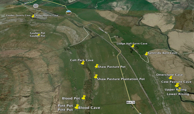
Map of area
